
A significant ice storm warning has been issued across a vast swath of the United States, bringing a dangerous mix of freezing rain, sleet, and snow. This major April winter storm is creating treacherous travel conditions and raising the risk of widespread power outages from the Plains through the Great Lakes and into the Carolinas. Millions of Americans are being urged to prepare for what could be a prolonged and hazardous event.
→ After FAFSA Chaos, Will History Repeat for 2026-27?
Key Takeaways
- Widespread Alerts: A potent storm system has triggered an ice storm warning, along with numerous winter storm watches and advisories, across more than a dozen states. Forecasters are particularly concerned about the Upper Midwest, including Minnesota, Wisconsin, and Michigan, as well as a separate system impacting the Carolinas.
- The Primary Threat is Ice: The most dangerous aspect of this storm is the potential for significant ice accumulation. The National Weather Service issues an ice storm warning when ice accretion of a quarter-inch or more is expected, a threshold that can snap tree limbs and bring down power lines.
- Holiday Travel Disruption: The timing of this storm is especially problematic, as it is set to disrupt travel plans leading into the Easter holiday weekend. Experts predict the possibility of thousands of flight cancellations and advise against road travel in the hardest-hit areas.
What Is Fueling This Major April Storm?
Our analysis of the meteorological data indicates that a slow-moving frontal system is the primary driver of this severe weather. This front is creating a battleground between lingering cold, sub-freezing air at the surface and warmer, moisture-laden air flowing in from the south. When rain from the warmer layer falls through this shallow pocket of cold air, it freezes on contact with surfaces like roads, trees, and power lines, leading to the dangerous ice accumulations currently forecasted.
This atmospheric setup is responsible for the messy mix of precipitation types. Areas to the north of the front are seeing heavy snow, while regions along the frontal boundary are experiencing the perilous combination of sleet and freezing rain. According to a report from AccuWeather, this clash of air masses is expected to persist for several days, prolonging the threat.
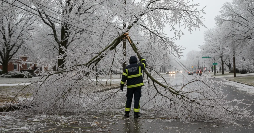
An Ice Storm Warning’s Two Biggest Threats: Travel and Power
An ice storm warning carries a dual threat that can bring a region to a standstill: impassable roads and major power outages. Even a thin glaze of ice can make highways and local streets nearly impossible to navigate safely, leading to accidents and closures. Authorities in Minnesota and Wisconsin have already warned that travel could be difficult to near impossible in some areas.
The second, and often more lasting, impact is on the power grid. As freezing rain accumulates, its weight on tree branches and power lines becomes immense. It takes only about a quarter of an inch of ice to create the same weight as 6 to 8 inches of heavy, wet snow, according to energy officials. This can lead to widespread and extended power outages as lines snap and transformers fail. Utility crews are on standby, but restoring power in the midst of an ice storm is one of the most dangerous jobs in America.
Which Regions Are Under the Highest Alert?
While the storm system is vast, our team has identified several epicenters where the impacts are expected to be most severe. The National Weather Service, which provides public alerts at Weather.gov, has issued detailed warnings for these specific zones.
| Region | Expected Accumulations | Primary Threats |
|---|---|---|
| Upper Midwest (MN, WI, MI) | 4-9 inches of snow/sleet; 0.2 to 0.4 inches of ice. | Dangerous travel on major corridors like I-35, significant power outage risk. |
| The Dakotas | 6-12 inches of snow, strong winds up to 40 mph. | Blizzard-like conditions, difficult travel, clinging snow weighing on infrastructure. |
| The Carolinas | Up to 0.25 inches of ice. | Widespread hazardous road conditions, potential for tree damage. |
| New Brunswick, Canada | 5-10 millimeters of freezing rain over 6-10 hours. | Icy surfaces, localized impacts on travel and infrastructure. |
This multi-faceted storm requires residents in all these areas to stay vigilant. The National Weather Service office in Duluth, MN, has been providing frequent updates on their social media channels, including their feed on X (formerly Twitter), as the situation evolves.
How to Prepare for the Coming Ice
With a major ice storm warning in effect, preparation is key to staying safe. Officials urge residents to avoid all non-essential travel. If you must drive, ensure your vehicle is equipped with an emergency kit, a full tank of gas, and that you check road conditions before departing.
At home, the primary concern is the potential for losing power for an extended period. Our team recommends the following steps:
* Gather Supplies: Stock up on non-perishable food, water, flashlights, batteries, and any necessary medications.
* Charge Devices: Fully charge all cell phones, laptops, and portable power banks.
* Prepare for Cold: Have blankets, sleeping bags, and warm clothing ready in case your heating system fails. Never use a generator or charcoal grill indoors.
* Stay Informed: Monitor updates from your local National Weather Service office and local news outlets. A battery-powered NOAA Weather Radio is a reliable source of information.
What This Means for Holiday Travel
The timing of this storm, just before the Easter weekend, is poised to create significant disruptions for travelers. AccuWeather forecasters have warned that thousands of flights could be delayed or canceled across major hubs in the Midwest. The combination of snow, sleet, and freezing rain will make road travel exceptionally dangerous, and our analysis suggests anyone with flexible plans should consider postponing their trip.
This late-season winter blast is a stark reminder that even as spring begins, high-impact weather can strike. The current ice storm warning is a serious threat that demands attention and preparedness from everyone in the storm’s path. We will continue to monitor the situation and provide updates as they become available. This powerful ice storm warning underscores the volatility of spring weather patterns. It is crucial for residents to heed the active ice storm warning and prioritize safety.
Relevant posts
- Lamar Odom Rewrites His Narrative in New Netflix Tell-All
- Millions Under Flood Watch: What You Need to Know Now
- LDS Church Revamps Sunday Schedule: What This Means for You
Visit atholtonnews.com for more stories.