
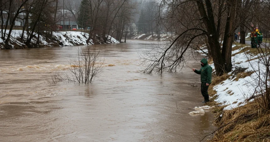
A potent combination of heavy rain and rapid snowmelt has placed millions of residents in Central New York and Ontario, Canada, under a significant flood watch. This developing situation, effective from this morning, Tuesday, March 31, 2026, through Wednesday evening, has prompted officials to urge vigilance as waterways are expected to rise, threatening low-lying and flood-prone areas with potential inundation.
→ LDS Church Revamps Sunday Schedule: What This Means for You
Key Takeaways
- Who is affected: A widespread flood watch is currently in effect for multiple counties across Central and Western New York, including Oneida, Jefferson, Monroe, and Erie, among others. In Canada, the Grand River Conservation Authority has issued a similar alert for the entire Grand River watershed.
- What is the cause: Forecasters predict a combination of 1 to 2 inches (50 to 60 mm in Canada) of rainfall and thunderstorms, coupled with runoff from melting snow. This is expected to cause rivers, creeks, and streams to swell and possibly overflow their banks.
- What to do: Residents in affected areas are advised to monitor forecasts closely, prepare for possible evacuations if warnings are issued, and never drive through flooded roadways.
Why Is This Flood Watch Happening Now?
Our analysis suggests that the primary driver behind this extensive flood watch is a perfect storm of meteorological conditions. A weather system is bringing periods of heavy rainfall and even thunderstorms directly over regions with a significant existing snowpack. As temperatures rise, the rain is accelerating the rate of snowmelt, releasing a large volume of water into the landscape in a very short period.
This rapid runoff is predicted to overwhelm natural and man-made drainage systems. Industry insiders are noting that the ground is already saturated from prior winter precipitation, leaving it with a reduced capacity to absorb the incoming water. This confluence of factors—heavy rain, rapid snowmelt, and saturated ground—creates a high-risk scenario for significant water level rises in rivers like the Mohawk and the Grand River, along with their smaller tributaries.
What Is the Difference Between a Flood Watch and a Warning?
Understanding the terminology used by meteorological agencies is key to your safety. The current situation is a flood watch, which means that conditions are favorable for flooding to develop. It does not mean flooding is already occurring, but it is a distinct possibility.
- Flood Watch: Be Prepared. This is the time to review your emergency plan, gather supplies, and stay informed through official sources like the National Weather Service.
- Flood Warning: Take Action. A flood warning is issued when flooding is imminent or already happening. If a warning is issued for your area, you must take immediate action, which may include evacuating to higher ground.
This distinction is critical; the current flood watch serves as a heads-up, giving residents valuable time to prepare before the situation potentially escalates. According to FEMA, being familiar with these terms and having a plan can significantly reduce risk.
Which Areas Are Most at Risk Under This Flood Watch?
Authorities have outlined specific areas of concern where the risk of flooding is most acute. These are typically low-lying regions, communities adjacent to major rivers and streams, and urban areas with poor drainage. The National Weather Service and the Grand River Conservation Authority (GRCA) have provided detailed information for residents.
Our team has compiled a summary of the key regions currently under alert:
| Region | Key Affected Counties/Areas | Issuing Authority |
|---|---|---|
| Central & Western New York | Oneida, Herkimer, Hamilton, Monroe, Erie, Jefferson, Lewis, Oswego & more. | National Weather Service |
| Grand River Watershed, ON | Grand Valley, Drayton, New Hamburg, Brantford, Six Nations, Cayuga & more. | Grand River Conservation Authority |
Residents in these zones, particularly those with past experiences of water encroachment, should be on high alert. You can find detailed, up-to-the-minute alerts from the National Weather Service and the Grand River Conservation Authority.
What Are the Official Safety Recommendations?
Emergency services emphasize that proactive measures are the best defense during a flood watch. The core message is to stay informed and be ready to act. Discussions on social media platforms like Reddit show that residents are actively seeking advice, with many experienced locals echoing official recommendations.
Key safety steps you should take now:
- Monitor Official Channels: Keep a close eye on forecasts from the National Weather Service and local news outlets. Have a battery-powered radio available in case of power outages.
- Prepare an Emergency Kit: This should include essentials like water, non-perishable food, medications, a flashlight, and important documents.
- Secure Your Property: If you are in a flood-prone area, consider moving valuable items to higher levels of your home. Ensure your sump pump is working and clear gutters and storm drains of debris.
- Plan Your Evacuation Route: Identify multiple routes to higher ground from your home and be prepared to leave if evacuation orders are given.
- Never Drive Through Floodwaters: The most crucial rule is “Turn Around, Don’t Drown.” It only takes about a foot of moving water to float a vehicle, and the road beneath the water may be washed out.
This flood watch is a serious event driven by a powerful weather system. Our team will continue to monitor the situation and provide updates as they become available. Staying prepared and heeding the advice of officials is the most effective way to ensure the safety of you and your family.
Relevant posts
- Walking Bus Kids School ICE Operations: Why it Matters Now
- Failure Means Build Resilient Software System: The 2026 Shift
- Production Occupations Jobs in Maryland: 2026 Growth Trends
Visit atholtonnews.com for more stories.